
Microwave imaging systems for monitoring soil water content and water extraction by plant roots.
Presentation
Soil moisture information is a key variable for describing water and energy exchanges at the
plant root/surface/air interface. In particular, monitoring the spatial variability of
soil moisture content with sub-meter resolution over time is important to increase
agriculture competitiveness, increase water efficiency and reduce pollution.
Characterizing this variability with conventional laboratory or in situ down-hole methods
is invasive, time-consuming and costly. Rapid and reliable methods which are adapted to
the monitoring of processes with time scales of the order of several minutes (preferential
flow, runoff) and for very heterogeneous soil spatial distribution (plant roots absorption,
digitations, ...) are not readily available, especially for highly saturated and/or high clay
content soils.
Intensive effort has been undertaken to provide non-invasive geophysical methods, in particular using microwave sensors.
Indeed, the real and imaginary part of the soil dielectric constant is linked to its volumetric water content
as well as its salinity. For example, remote sensing systems can provide estimates of surface soil moisture
on a daily basis and regional scale but are affected by surface rugosity, vegetation cover.
GPR has also been used increasingly to assist in subsurface hydraulic parameter identification.
But using a pulse signal has some limitation such as dispersion effects or a sampling volume changing with wavelength.
The goal of the CESAR project is to demonstrate the potentiality of a non-invasive microwave imaging system for
water content monitoring, with an expected spatial resolution of the order of cm, with acquisition time of the
order of the minute and a penetration depth up to the root zone. The purpose is to provide a complementary
non-invasive measurement setup for intermediate scales between remote sensing scales and ground truth measurement scales.
The obtained dielectric constant maps will help to improve the understanding in fluid flow modeling as well as
the soil water extraction by plant roots.
This project benefits from an interdisciplinary collaboration
between the following teams :
- HIPE group
"Transfers in heterogeneous media" team from the "Climat, Soil and Environment" laboratory of INRA, Avignon
"Electromagnetic Group" of INTEC from Gent University in Belgium- Geophysic division from CEREGE
This project has been selected by the
ANR Jeunes Chercheurs 2006 and has therefore received a grant
for the 2007-2010 period.
Experimental setups
Due to the expected spatial and temporal scales, we have decided to use only harmonic
waves in order to take benefit of the following points:
- a simplification of the modeling part
(homogenization with a single scale related to the wavelength, ...) - a simplification of the extraction
of the imaginary part of the permittivity (no dispersion issue) - to be able in the future to use multi-sources
and multi-receivers configuration without a network analyzer
This choice has greatly determined
the experimental setups, the first one is a circular scanner,
the second one is very close to a realistic configuration with
antennas positioned above the ground.
These two setups have the same specificities:
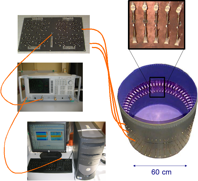
- a multiplexer/demultiplexer device
in order to visualize rapidly the evolution of water content within the probed region, - a large number of antennas which can
act as receivers or emitters, - short acquisition time in order to obtain rapidly
permittivity maps and therefore be able to monitor in time the water process.
The project contains a large
experimental part with the development of these various setups:
|
 |
Numerical developments
An imaging system consists necessarily of two complementary parts: data acquisition and data treatment.
This implies that the development of modeling and inversion algorithms must be done in close relationships
with the definition of the setups.
When it is raining or when the plant absorbs water, there are changes in the water content/salinity of
the soil and therefore in the underground complex permittivity. This variation will induce a change in
the measured scattered field. It is therefore of interest to have access to modeling codes which
will predict the variation of the scattered field for a variation of a given permittivity (
direct problem). On the contrary, it is interesting to be able to determine
a permittivity variation for a given scattered field variation (inverse problem).
- Forward problem
In the cylindrical scanner, the presence of the
metallic boundaries must be taken into account in the computations.
Several algorithms adapted to this 2D configuration have already been established with very
satisfactory results:
- Moments methods with the Green function of the
circular metallic cylinder
[Geffrin, 1995] - Moments methods with free space Green function
coupled with a de-embedding technique
[Tijhuis et al., 1999] - Finite element code developed at Institut Fresnel
by Hervé Tortel.
src="IMG/gif/test2.gif">
Propagation
of a monochromatic wave inside the circular scanner in presence of a soil column
If the bi-dimensionnal assumption is no
more valid, as for example for the XY scanner, a 3D modeling code is currently being
developed based on finite element techniques.
- Inverse problem
Unfortunately recovering the complex permittivity of a medium from its measured
scattered field is an ill-posed and non linear inverse problem. This ill-posedness can be partly compensated
by adding all the a-priori information available. Here we want to tightly couple all the underlying physical
processes such as electromagnetic scattering or fluid flow modeling in porous media in order
to obtain permittivity maps with a spatial resolution of a few cm.
We are using qualitative imaging techniques which are fast and
very robust to noise. This is the case for example of the DORT method (Operateur de retournement temporel) which
provides information on the strongest scatterers.
src="IMG/png/valeurpropreDort.png">
Images obtained with the first three eigenvalues
of the DORT methods
for water columns placed within a soil column (εr=12+5j)
In order to provide more accurate information on the probed
region, we are using quantitative reconstruction algorithms which provides permittivity maps thanks to
iterative minimization schemes.
src="IMG/jpg/permittivite.jpg">
Images obtained at the end of a
iterative minimization process such as conjugate-gradient scheme
for water columns placed within a soil column (εr=12+5j)
Publications
-
"Imposing zernike representation for two-dimensional targets imaging",
R Lencrerot, A Litman, H Tortel, and J-M Geffrin,
Inverse Problems, 25:035012, 2009. -
"Measurement strategies for a confined microwave circular scanner",
R Lencrerot, A Litman, H Tortel and J-M Geffrin,
Inverse Problems in Science and Engineering, 357869, 2009. -
"On embedded microwave imaging systems: retrievable information and design guidelines",
L Crocco and A Litman,
Inverse Problems, 25:065001, 2009. -
"Combining spatial support information and shape-based method for tomographic imaging inside a microwave cylindrical scanner",
R Lencrerot, A Litman, and J-M Geffrin,
Inverse Problems in Science and Engineering, 18:19-34, 2010.
Conferences
-
"A microwave imaging circular setup for soil
moisture information",
R. Lencrerot, A. Litman, H. Tortel, J.-M. Geffrin,
IEEE Int. Geoscience Remote Sens. Proc., pp. 4394-4397, Barcelona, Spain, 2007 -
"On the use of Zernike basis functions for imaging in a cylindrical configuration"
R. Lencrerot, A. Litman, H. Tortel
Inverse Problem: Modeling and Simulation Conf., pp. 112-113, Fethiye, Turkey, 2008 -
"Level-set imaging in a metallic cylindrical cavity configuration"
R. Lencrerot, A. Litman, H. Tortel
Inverse Problem: Modeling and Simulation Conf., pp. 114-115, Fethiye, Turkey, 2008 -
"Imaging soil inside a cylindrical microwave scanner: first results
with phantoms"
R. Lencrerot, A. Litman, H. Tortel, J.M. Geffrin, J. Zbitou
IEEE Int. Geoscience Remote Sens. Proc., Boston, USA, 2008 -
"DORT method as an imaging tool for extended targets"
X. Zhang, H. Tortel, J-M. Geffrin, P. Sabouroux
PIERS pp. 374, Boston, USA, 2008 -
"Using circular support information for microwave imaging"
R. Lencrerot, A. Litman, H. Tortel and JM. Geffrin
PIERS pp. 224, Boston, USA, 2008 -
"Circular microwave imaging setup for retrieving soil moisture content"
R. Lencrerot, A. Litman, H. Tortel and JM. Geffrin
PIERS pp. 465, Hangzhou, China, 2008
 ResearchGate
 Flux RSS